
Silesian Voivodeship topographic map
Interactive map
Click on the map to display elevation.
About this map
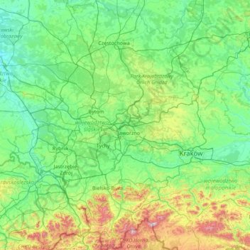
Name: Silesian Voivodeship topographic map, elevation, terrain.
Location: Silesian Voivodeship, Poland (49.39398 18.03503 51.09943 19.97407)
Average elevation: 337 m
Minimum elevation: 150 m
Maximum elevation: 1,619 m
Other topographic maps
Click on a map to view its topography, its elevation and its terrain.
Katowice
Poland > Silesian Voivodeship > Katowice
Katowice, GZM, Silesian Voivodeship, Poland
Average elevation: 275 m