
Ido-Osi topographic map
Interactive map
Click on the map to display elevation.
About this map
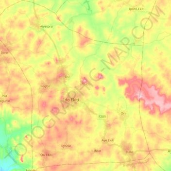
Name: Ido-Osi topographic map, elevation, terrain.
Location: Ido-Osi, Ekiti State, Nigeria (7.77096 5.09416 7.95235 5.26565)
Average elevation: 553 m
Minimum elevation: 433 m
Maximum elevation: 665 m
Other topographic maps
Click on a map to view its topography, its elevation and its terrain.
Ikere-Ekiti
Nigeria > Ekiti State > Ikere
Ikere-Ekiti, Ikere, Ekiti State, Nigeria
Average elevation: 374 m
Irepodun/Ifelodun
Irepodun/Ifelodun, Ekiti State, Nigeria
Average elevation: 478 m