
Thank you for supporting this site ❤️
Make a donation
Make a donation
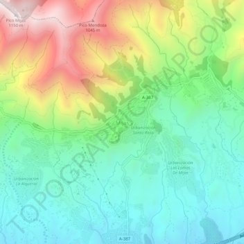
Mijas topographic map
Click on the map to display elevation.
Thank you for supporting this site ❤️
Make a donation
Make a donation
Mijas
The climate changes gradually with increasing elevation in the mountains. Temperatures can drop to 10 °C (50 °F). In the peaks, over 600 m (2,000 ft) high, some ice may form in winter, while precipitation increases to almost 800 mm (32 in).
Thank you for supporting this site ❤️
Make a donation
Make a donation
About this map
Name: Mijas topographic map, elevation, terrain.
Average elevation: 447 m
Minimum elevation: 97 m
Maximum elevation: 1,142 m
Thank you for supporting this site ❤️
Make a donation
Make a donation