
Make a donation
Skogafoss topographic map
Click on the map to display elevation.
Make a donation
About this map
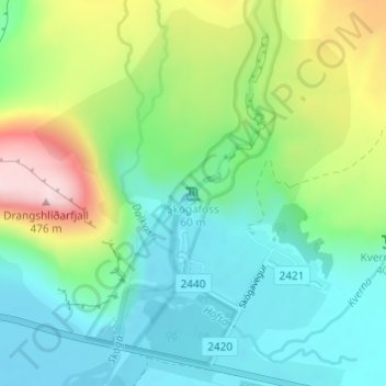
Name: Skogafoss topographic map, elevation, terrain.
Location: Skogafoss, Rangárþing eystra, Southern Region, Iceland (63.53205 -19.51134 63.53215 -19.51124)
Average elevation: 145 m
Minimum elevation: 17 m
Maximum elevation: 459 m
Make a donation
Other topographic maps
Click on a map to view its topography, its elevation and its terrain.
Eyjafjallajökull
Eyjafjallajökull (Icelandic: (listen); lit. 'glacier of the mountains of the islands') is one of the smaller ice caps of Iceland, north of Skógar and west of Mýrdalsjökull. The ice cap covers the caldera of a volcano with a summit elevation of 1,651 metres (5,417 ft). The volcano has erupted relatively…
Average elevation: 819 m
Eyjafjallajökul
Eyjafjallajökull (Icelandic: [ˈeiːjaˌfjatl̥aˌjœːkʏtl̥] ; "glacier of (the mountain) Eyjafjöll"), sometimes referred to by the numeronym E15, is one of the smaller ice caps of Iceland, north of Skógar and west of Mýrdalsjökull. The ice cap covers the caldera of a volcano with a summit elevation of…
Average elevation: 819 m