
Rio Grande topographic map
Interactive map
Click on the map to display elevation.
About this map
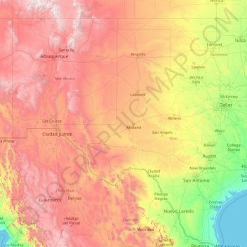
Name: Rio Grande topographic map, elevation, terrain.
Location: Rio Grande, Reeves County, Texas, 88006, USA (25.83706 -107.54317 37.82449 -97.14506)
Average elevation: 1,042 m
Minimum elevation: -1 m
Maximum elevation: 4,035 m
Other topographic maps
Click on a map to view its topography, its elevation and its terrain.
Point Loma
USA > Texas > Point Loma
Point Loma, San Patricio County, Texas, 78368, USA
Average elevation: 34 m
Denny Mountain
Denny Mountain, Nacogdoches County, Texas, 75760, USA
Average elevation: 137 m
Karnes City
USA > Texas > Karnes City
Karnes City, Karnes County, Texas, 78118, USA
Average elevation: 122 m
San Jacinto Mountain
San Jacinto Mountain, Presidio County, Texas, USA
Average elevation: 1,233 m
Guadalupe Peak
Guadalupe Peak, Culberson County, Texas, 79847, USA
Average elevation: 2,151 m