
Make a donation
Baja California Peninsula topographic map
Click on the map to display elevation.
Make a donation
About this map
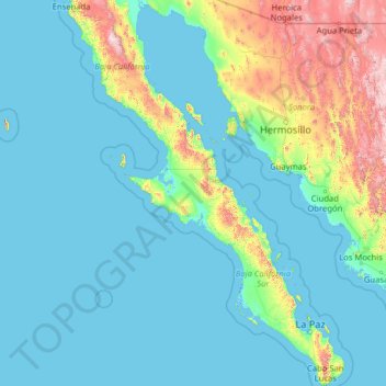
Name: Baja California Peninsula topographic map, elevation, terrain.
Location: Baja California Peninsula, Mexico (22.87163 -116.74417 31.85802 -109.41319)
Average elevation: 224 m
Minimum elevation: -3 m
Maximum elevation: 2,848 m
Make a donation
Other topographic maps
Click on a map to view its topography, its elevation and its terrain.
Toluca
Mexico > State of Mexico > Toluca
Toluca is located at 2600 meters above sea level, being the highest capital city in Mexico and North America, which makes it temperate throughout the year with average temperatures ranging between 6 and 25 degrees Celsius during spring and summer, and from −5 to 20 degrees Celsius in winter. Its climate is…
Average elevation: 2,729 m
San Mateo Coapexco, Villa Guerrero Edo. Mex.
Mexico > State of Mexico > Villa Guerrero > San Mateo Coapexco, Villa Guerrero Edo. Mex.
Average elevation: 2,176 m
Make a donation