
Abia State topographic map
Interactive map
Click on the map to display elevation.
About this map
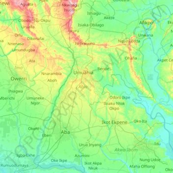
Name: Abia State topographic map, elevation, terrain.
Location: Abia State, Nigeria (4.82302 7.14043 6.04215 7.98750)
Average elevation: 75 m
Minimum elevation: 0 m
Maximum elevation: 433 m
Other topographic maps
Click on a map to view its topography, its elevation and its terrain.
Lagos
Nigeria > Lagos State > Lagos Island
Lagos, Lagos Island, Lagos State, 100242, Nigeria
Average elevation: 5 m
Oju Ota
Nigeria > Ogun State > Yewa South
Oju Ota, Yewa South, Ogun State, Nigeria
Average elevation: 40 m
Itere
Nigeria > Ogun State > Ado Odo/Ota
Itere, Ado Odo/Ota, Ogun State, Nigeria
Average elevation: 7 m
Ashaka
Nigeria > Gombe State > Funakaye
Ashaka, Funakaye, Gombe State, Nigeria
Average elevation: 260 m
Ikare
Nigeria > Ondo State > Akoko North East
Ikare, Akoko North East, Ondo State, Nigeria
Average elevation: 440 m
Birnin Kudu
Nigeria > Jigawa State > Birnin Kudu
Birnin Kudu, Jigawa State, Nigeria
Average elevation: 438 m
Gargada
Nigeria > Jigawa State > Birnin Kudu
Gargada, Birnin Kudu, Jigawa State, Nigeria
Average elevation: 418 m
Tafan
Nigeria > Plateau State > Barkin Ladi
Tafan, Barkin Ladi, Plateau State, Nigeria
Average elevation: 1,237 m
Oworonṣoki
Nigeria > Lagos State > Kosofe
Oworonṣoki, Kosofe, Lagos State, 100234, Nigeria
Average elevation: 4 m
Asejire Reservoir
Nigeria > Osun State > Irewole
Asejire Reservoir, Irewole, Osun State, Nigeria
Average elevation: 175 m
Gwafan
Nigeria > Plateau State > Jos North
Gwafan, Jos North, Plateau State, 930106, Nigeria
Average elevation: 1,304 m
Kaltungo
Nigeria > Gombe State > Kaltungo
Kaltungo, Gombe State, 770109, Nigeria
Average elevation: 499 m
Lim Kundak
Nigeria > Bauchi State > Alkaleri
Lim Kundak, Alkaleri, Bauchi State, Nigeria
Average elevation: 412 m
Itamoga
Nigeria > Lagos State > Ikorodu
Itamoga, Ikorodu, Lagos State, 104214, Nigeria
Average elevation: 31 m
Yerimaru
Nigeria > Taraba State > Sardauna
Yerimaru, Sardauna, Taraba State, Nigeria
Average elevation: 1,446 m
Aviara
Nigeria > Delta State > Isoko South
Aviara, Isoko South, Delta State, Nigeria
Average elevation: 11 m
Calabash Island
Nigeria > Lagos State > Amuwo Odofin
Calabash Island, Amuwo Odofin, Lagos State, 101001, Nigeria
Average elevation: 10 m
Sangotedo
Nigeria > Lagos State > Eti Osa
Sangotedo, Eti Osa, Lagos State, 101245, Nigeria
Average elevation: 5 m
Amaeke Abam
Nigeria > Abia State > Arochukwu
Amaeke Abam, Arochukwu, Abia State, Nigeria
Average elevation: 78 m
Kuje
Nigeria > Federal Capital Territory
Kuje, Federal Capital Territory, Nigeria, Usuma
Average elevation: 252 m
Omu Aran
Nigeria > Kwara State > Irepodun
Omu Aran, Irepodun, Kwara State, 251101, Nigeria
Average elevation: 539 m