
Make a donation
Hunsrück topographic map
Click on the map to display elevation.
Make a donation
About this map
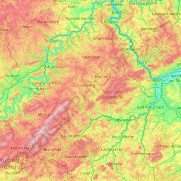
Name: Hunsrück topographic map, elevation, terrain.
Location: Hunsrück, Rhineland-Palatinate, Germany (49.51488 6.59316 50.31777 7.87444)
Average elevation: 352 m
Minimum elevation: 66 m
Maximum elevation: 817 m
Make a donation
Other topographic maps
Click on a map to view its topography, its elevation and its terrain.
Nürburg
Germany > Rhineland-Palatinate > Landkreis Ahrweiler
Nürburg has a semi-continental climate with both oceanic and continental tendencies. It does however land in the former category (Köppen Cfb). With regards to the racetrack, due to the Nordschleife's varied terrain and elevation, weather may be completely different on either end of the track. The elevation…
Average elevation: 560 m
Make a donation
Eifel
Germany > Rhineland-Palatinate > Landkreis Ahrweiler > Adenau
The Eifel is in the Atlantic climate zone with its relatively high precipitation; winters that are moderately cold and long with periods of snow; and summers that are often humid and cool. The prevailing wind is west/southwest. A relatively dry and milder climate prevails in the wind and rain shadow of the…
Average elevation: 585 m
Make a donation
Mainz
Germany > Rhineland-Palatinate
Nevertheless, the post-war reconstruction took place very slowly. While cities such as Frankfurt had been rebuilt fast by a central authority, only individual efforts were initially successful in rebuilding Mainz. The reason for this was that the French wanted Mainz to expand and become a model city. Mainz lay…
Average elevation: 132 m
Make a donation
Ramstein-Miesenbach
Germany > Rhineland-Palatinate > Landkreis Kaiserslautern
Average elevation: 266 m
Make a donation
Make a donation
Rhine Gorge
Germany > Rhineland-Palatinate > Rhein-Hunsrück-Kreis > Sankt Goar > Biebernheim
Average elevation: 177 m
Air Base
Germany > Rhineland-Palatinate > Landkreis Kaiserslautern > Ramstein-Miesenbach
Average elevation: 237 m
Make a donation
Deidesheim
Germany > Rhineland-Palatinate > Landkreis Bad Dürkheim
From a local climatic point of view, Deidesheim is part of the climatically favoured foothill zone of the Weinstraße region. With a mean elevation of 235 m above sea level at the forest's edge, the lands of the Deidesheim area reach down to some 130 m above sea level at the lower mid-slope area in the…
Average elevation: 194 m
Make a donation
Make a donation
Eifel
Germany > Rhineland-Palatinate > Landkreis Ahrweiler > Adenau
The Eifel is in the Atlantic climate zone with its relatively high precipitation; winters that are moderately cold and long with periods of snow; and summers that are often humid and cool. The prevailing wind is west/southwest. A relatively dry and milder climate prevails in the wind and rain shadow of the…
Average elevation: 585 m
Make a donation
Friedewald
Germany > Rhineland-Palatinate > Landkreis Altenkirchen (Westerwald)
Average elevation: 484 m
Make a donation
Wingendorf
Germany > Rhineland-Palatinate > Landkreis Altenkirchen (Westerwald)
Average elevation: 285 m
Waldfischbach
Germany > Rhineland-Palatinate > Südwestpfalz > Waldfischbach-Burgalben
Average elevation: 326 m
Make a donation
Make a donation
Carlsberg
Germany > Rhineland-Palatinate > Landkreis Bad Dürkheim
The municipality lies at the north edge of the Palatinate Forest between the Haardt range in the south and the Autobahn A 6 in the north in the Leiningerland at an elevation of 285 m above sea level. Carlsberg belongs to the Verbandsgemeinde of Leiningerland, whose seat is in Grünstadt.
Average elevation: 327 m
Nürburg
Germany > Rhineland-Palatinate > Landkreis Ahrweiler
Nürburg has a semi-continental climate with both oceanic and continental tendencies. It does however land in the former category (Köppen Cfb). With regards to the racetrack, due to the Nordschleife's varied terrain and elevation, weather may be completely different on either end of the track. The elevation…
Average elevation: 560 m
Make a donation
Make a donation
Mainz
Germany > Rhineland-Palatinate
The destruction caused by the Bombing of Mainz in World War II led to the most intense phase of building in the history of the town. During the last war in Germany, more than 30 air raids destroyed about 80 per cent of the city's centre, including most of the historic buildings. The attack on the afternoon of…
Average elevation: 132 m
Westerwald
Germany > Rhineland-Palatinate
The Westerwald (German pronunciation: ; literally 'Western forest') is a low mountain range on the right bank of the river Rhine in the German federal states of Rhineland-Palatinate, Hesse and North Rhine-Westphalia. It is a part of the Rhenish Massif (Rheinisches Schiefergebirge or Rhenish Slate Mountains).…
Average elevation: 290 m
Ahr
Germany > Rhineland-Palatinate
Ahr (German pronunciation: [ˈaːɐ̯]) is a river in Germany, a left tributary of the Rhine. Its source is at an elevation of approximately 470 metres (1,540 ft) above sea level in Blankenheim in the Eifel, in the cellar of a timber-frame house near the castle of Blankenheim. After 18 kilometres (11 mi) it…
Average elevation: 367 m
Make a donation
Westerwald
Germany > Rhineland-Palatinate
The Westerwald (German pronunciation: [ˈvɛstɐvalt] ; literally 'Western forest') is a low mountain range on the right bank of the river Rhine in the German federal states of Rhineland-Palatinate, Hesse and North Rhine-Westphalia. It is a part of the Rhenish Massif (Rheinisches Schiefergebirge or Rhenish…
Average elevation: 290 m
Make a donation
Weiperath
Germany > Rhineland-Palatinate > Landkreis Bernkastel-Wittlich > Morbach
The municipality lies at an elevation of between 430 and 770 m above sea level in the low mountain range of the Hunsrück on the boundary with the Birkenfeld district, roughly 25 km southeast of Wittlich and 35 km east of Trier. Its population is 11,051. The nearest town is Bernkastel-Kues.
Average elevation: 439 m
Hinterhausen
Germany > Rhineland-Palatinate > Landkreis Vulkaneifel > Gerolstein
Average elevation: 455 m
Make a donation
Ramstein-Miesenbach
Germany > Rhineland-Palatinate > Landkreis Kaiserslautern
Average elevation: 266 m
Make a donation
Mainz
Germany > Rhineland-Palatinate
The destruction caused by the Bombing of Mainz in World War II led to the most intense phase of building in the history of the town. During the last war in Germany, more than 30 air raids destroyed about 80 per cent of the city's centre, including most of the historic buildings. The attack on the afternoon of…
Average elevation: 131 m
Make a donation
Make a donation
Make a donation
Erbel
Germany > Rhineland-Palatinate > Landkreis Altenkirchen (Westerwald) > Fluterschen
Average elevation: 281 m
Make a donation
Mainz
Germany > Rhineland-Palatinate
The destruction caused by the Bombing of Mainz in World War II led to the most intense phase of building in the history of the town. During the last war in Germany, more than 30 air raids destroyed about 80 per cent of the city's centre, including most of the historic buildings. The attack on the afternoon of…
Average elevation: 132 m
Make a donation
Hochstadt (Pfalz)
Germany > Rhineland-Palatinate > Landkreis Südliche Weinstraße
Average elevation: 133 m
Make a donation
Heldberg
Germany > Rhineland-Palatinate > Landkreis Trier-Saarburg > Klüsserath
Average elevation: 215 m
Cochem
Germany > Rhineland-Palatinate > Landkreis Cochem-Zell
Cochem lies at an elevation of some 83 m above sea level and the municipal area measures 21.2 km2. The town centre with the outlying centre of Sehl upstream lies on the Moselle's left bank, while the constituent centre of Cond lies on its right. A further constituent centre, Brauheck, with its commercial area,…
Average elevation: 286 m
Make a donation