
Kathmandu topographic map
Interactive map
Click on the map to display elevation.
About this map
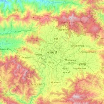
Name: Kathmandu topographic map, elevation, terrain.
Location: Kathmandu, Bagmati, Central Development Region, 44600, Nepal (27.54880 85.16024 27.86880 85.48024)
Average elevation: 1,536 m
Minimum elevation: 489 m
Maximum elevation: 2,735 m
Other topographic maps
Click on a map to view its topography, its elevation and its terrain.
Kathmandu
Nepal > Central Development Region > Kathmandu
Kathmandu, Bagmati, Central Development Region, Nepal
Average elevation: 1,331 m