
Thank you for supporting this site ❤️
Make a donation
Make a donation
Perimetro Urbano Pereira topographic map
Click on the map to display elevation.
Thank you for supporting this site ❤️
Make a donation
Make a donation
Perimetro Urbano Pereira
Pereira, like many Colombian cities, has high-elevation areas with difficult access or flat or steep parts. The streets are laid out according to the elevation of the respective zones.
Thank you for supporting this site ❤️
Make a donation
Make a donation
About this map
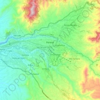
Name: Perimetro Urbano Pereira topographic map, elevation, terrain.
Average elevation: 1,486 m
Minimum elevation: 1,202 m
Maximum elevation: 2,104 m
Thank you for supporting this site ❤️
Make a donation
Make a donation