
Thank you for supporting this site ❤️
Make a donation
Make a donation
Saint-Gilles - Sint-Gillis topographic map
Click on the map to display elevation.
Thank you for supporting this site ❤️
Make a donation
Make a donation
About this map
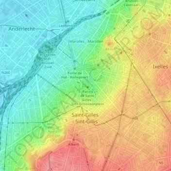
Name: Saint-Gilles - Sint-Gillis topographic map, elevation, terrain.
Location: Saint-Gilles - Sint-Gillis, Brussels-Capital, 1060, Belgium (50.82000 4.32648 50.84024 4.35886)
Average elevation: 58 m
Minimum elevation: 18 m
Maximum elevation: 106 m
Thank you for supporting this site ❤️
Make a donation
Make a donation
Other topographic maps
Click on a map to view its topography, its elevation and its terrain.
Woluwe Park
Belgium > Brussels-Capital > Woluwe-Saint-Pierre - Sint-Pieters-Woluwe
Average elevation: 73 m
Thank you for supporting this site ❤️
Make a donation
Make a donation
Thank you for supporting this site ❤️
Make a donation
Make a donation
Boitsfort - Bosvoorde
Belgium > Brussels-Capital > Watermael-Boitsfort - Watermaal-Bosvoorde
Average elevation: 96 m
Molenbeek-Saint-Jean - Sint-Jans-Molenbeek
Belgium > Brussels-Capital > Molenbeek-Saint-Jean - Sint-Jans-Molenbeek
Average elevation: 47 m
Parc de Laeken - Park van Laken
Belgium > Brussels-Capital > Brussels > Laeken - Laken
Average elevation: 47 m
Thank you for supporting this site ❤️
Make a donation
Make a donation