
Thank you for supporting this site ❤️
Make a donation
Make a donation
Marion County topographic map
Click on the map to display elevation.
Thank you for supporting this site ❤️
Make a donation
Make a donation
About this map
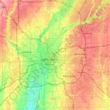
Name: Marion County topographic map, elevation, terrain.
Location: Marion County, Indiana, United States (39.63216 -86.32812 39.92753 -85.93804)
Average elevation: 241 m
Minimum elevation: 196 m
Maximum elevation: 282 m
Thank you for supporting this site ❤️
Make a donation
Make a donation
Other topographic maps
Click on a map to view its topography, its elevation and its terrain.