
Thank you for supporting this site ❤️
Make a donation
Make a donation
Lubbeek topographic map
Click on the map to display elevation.
Thank you for supporting this site ❤️
Make a donation
Make a donation
About this map
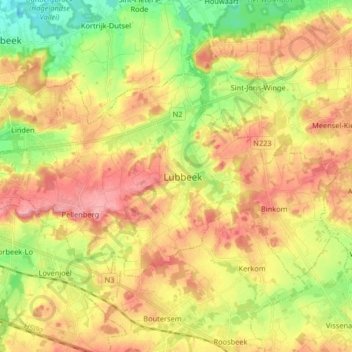
Name: Lubbeek topographic map, elevation, terrain.
Location: Lubbeek, Leuven, Flemish Brabant, Flanders, Belgium (50.85171 4.74794 50.91175 4.91113)
Average elevation: 61 m
Minimum elevation: 8 m
Maximum elevation: 107 m
Thank you for supporting this site ❤️
Make a donation
Make a donation
Other topographic maps
Click on a map to view its topography, its elevation and its terrain.
Doode Bemde
Belgium > Flemish Brabant > Leuven > Oud-Heverlee > Sint-Joris-Weert
Average elevation: 48 m