
Podlaskie Voivodeship topographic map
Interactive map
Click on the map to display elevation.
About this map
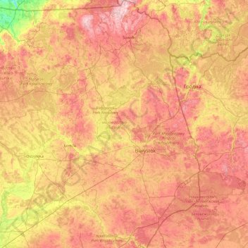
Name: Podlaskie Voivodeship topographic map, elevation, terrain.
Location: Podlaskie Voivodeship, Poland (52.27994 21.59284 54.41040 23.94627)
Average elevation: 138 m
Minimum elevation: 30 m
Maximum elevation: 290 m
It has a varied landscape, shaped in the north by Baltic glaciation, the rest by Middle Poland glaciation. The highest peaks are in the north (Rowelska Top - 298 m), where the landscape is dominated by a hilly lake district. Lakeland: Zachodniosuwalskie, Wschodniosuwalskie, Ełckie) and Sandrowy lake district (Augustów Plain) in the central and southern pre-glacial plains prevail (plateaus: Kolneńska, Białystok, Wysokomazowiecka, Drohiczynska, Sokólskie Hills, Międzyrzecko łomżyński, Plain Bielsko), varied in topography with small basins and river valleys. Kurpie lie on the west edge of the outwash plains. Sand, gravel, clay, moraine, and in the valleys and basins of the rivers silt, sand and river peat predominate on the surface.
Other topographic maps
Click on a map to view its topography, its elevation and its terrain.
Sejny
Poland > Podlaskie Voivodeship > Sejny
Sejny, powiat sejneński, Podlaskie Voivodeship, 16-500, Poland
Average elevation: 136 m