Make a donation
Busselton topographic map
Click on the map to display elevation.
Make a donation
About this map
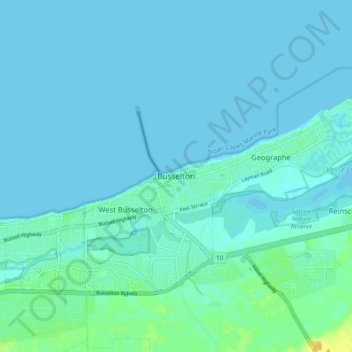
Name: Busselton topographic map, elevation, terrain.
Location: Busselton, City Of Busselton, Western Australia, Australia (-33.68450 115.30888 -33.60450 115.38888)
Average elevation: 4 m
Minimum elevation: 0 m
Maximum elevation: 24 m
Make a donation
Other topographic maps
Click on a map to view its topography, its elevation and its terrain.
Make a donation
Make a donation
Fremantle Inner Harbour
Australia > Western Australia > City of Fremantle > Fremantle
Average elevation: 7 m
Make a donation
Make a donation
Stirling Range National Park
The park is particularly rich in banksias, eucalypts, orchids and verticordias. Ten species of mountain bells (Darwinia spp.) have been identified in the park and only one of these is found outside Stirling Range. Five major vegetation communities are known in the park with thicket and mallee-heath at higher…
Average elevation: 235 m
Kumpupintil Lake
The 33,000-hectare (82,000-acre) lake typically is dry, except during very wet periods such as the 1900 floods and in many recent tropical wet seasons since 1967. It lies on the Tropic of Capricorn, due east of the mining town of Newman and the Jigalong Community. It is at the northern side of the Little Sandy…
Average elevation: 346 m
Make a donation
Make a donation
Make a donation
Make a donation
Make a donation
Make a donation
Make a donation
Katanning
Katanning railway station has an elevation of 1,024 feet (312 m) above sea level and a rail distance of 225 miles (362 km) from Perth.
Average elevation: 323 m
Make a donation
Make a donation
Make a donation
Make a donation
Make a donation
Make a donation
Make a donation
Make a donation
Make a donation
Make a donation
Make a donation
Make a donation
Make a donation
Make a donation
