
Thank you for supporting this site ❤️
Make a donation
Make a donation
Vievola topographic map
Click on the map to display elevation.
Thank you for supporting this site ❤️
Make a donation
Make a donation
About this map
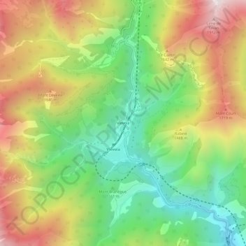
Name: Vievola topographic map, elevation, terrain.
Average elevation: 1,333 m
Minimum elevation: 829 m
Maximum elevation: 1,973 m
Thank you for supporting this site ❤️
Make a donation
Make a donation
Other topographic maps
Click on a map to view its topography, its elevation and its terrain.
Forte Colle Alto
France > Provence-Alpes-Côte d'Azur > Maritime Alps > Tende
Average elevation: 1,688 m