
Masovian Voivodeship topographic map
Interactive map
Click on the map to display elevation.
About this map
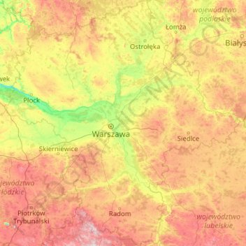
Name: Masovian Voivodeship topographic map, elevation, terrain.
Location: Masovian Voivodeship, Poland (51.01314 19.25921 53.48181 23.12841)
Average elevation: 146 m
Minimum elevation: 51 m
Maximum elevation: 400 m
Other topographic maps
Click on a map to view its topography, its elevation and its terrain.
Radom County
Poland > Masovian Voivodeship > Radom County
Radom County, Masovian Voivodeship, Poland
Average elevation: 179 m
Praga-Południe
Poland > Masovian Voivodeship > Warsaw
Praga-Południe, Warsaw, Warszawa, Masovian Voivodeship, Poland
Average elevation: 86 m
Radom
Poland > Masovian Voivodeship > Radom
Radom, Masovian Voivodeship, Poland
Average elevation: 168 m