
Make a donation
Quebec topographic map
Click on the map to display elevation.
Make a donation
Quebec
Quebec's topography is characterized by three main physiographic regions: the Canadian Shield, the St. Lawrence Lowlands, and the Appalachian Mountains. The Canadian Shield, covering about 90% of the province, features rugged terrain with rocky plateaus, rolling hills, and numerous rivers and lakes formed by glacial erosion. The St. Lawrence Lowlands, concentrated around the St. Lawrence River, offer relatively flat and fertile land, making it ideal for agriculture and urban development. In the southeast, the Appalachian region consists of rounded mountains, deep valleys, and forested plateaus. The province's highest point is Mont d'Iberville (Mount Caubvick), reaching 1,652 meters (5,420 feet) in the Torngat Mountains of northern Quebec. This diverse terrain contributes to Quebec's rich natural landscapes and varied ecosystems.
Make a donation
About this map
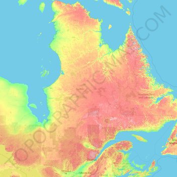
Name: Quebec topographic map, elevation, terrain.
Location: Quebec, Canada (44.99137 -79.76287 62.58250 -57.10749)
Average elevation: 195 m
Minimum elevation: -2 m
Maximum elevation: 1,383 m
Make a donation
Other topographic maps
Click on a map to view its topography, its elevation and its terrain.
Toronto
Despite its deep ravines, Toronto is not remarkably hilly, but its elevation does increase steadily away from the lake. Elevation differences range from 76.5 metres (251 ft) above sea level at the Lake Ontario shore to 209 m (686 ft) ASL near the York University grounds in the city's north end at the…
Average elevation: 113 m
London
Canada > Ontario > London > London
London has a humid continental climate (Köppen Dfb), though due to its downwind location relative to Lake Huron and elevation changes across the city, it is virtually on the Dfa/Dfb (hot summer) boundary favouring the former climate zone to the southwest of the confluence of the South and North Thames Rivers,…
Average elevation: 268 m
Make a donation
Mount Royal
Canada > Quebec > Urban agglomeration of Montreal > Montreal
The hill is part of the Monteregian Hills situated between the Laurentians and the Appalachian Mountains. It gave its Latin name, Mons Regius, to the Monteregian chain. The hill consists of three peaks: Colline de la Croix (or Mont Royal proper) at 233 m (764 ft), Colline d'Outremont (or Mount Murray, in the…
Average elevation: 111 m
Guelph
This region of Ontario has cold winters and warm, humid summers, falling into the Köppen climate classification Dfb zone, with moderately high rainfall and snowfall. It is generally a couple of degrees cooler than lower elevation regions on the Great Lakes shorelines, especially so in winter, the exception…
Average elevation: 344 m
Banff
Canada > Alberta > Banff > Banff
Banff is a town within Banff National Park in Alberta, Canada. It is located in Alberta's Rockies along the Trans-Canada Highway, approximately 126 km (78 mi) west of Calgary and 58 km (36 mi) east of Lake Louise. At 1,400 to 1,630 m (4,590 to 5,350 ft) above sea level, Banff is the community with the second…
Average elevation: 1,615 m
Make a donation
70 Mile House
Canada > British Columbia > Thompson-Nicola Regional District > Area E (Bonaparte Plateau)
Average elevation: 1,087 m
Make a donation
Make a donation
Riding Mountain National Park
The climate in the Riding Mountain region is similar to that of other regions of southwestern Manitoba. Under the Köppen classification it has a continental climate. It includes grasslands, upland boreal and eastern deciduous forest ecosystems. The park has hot summers and cold winters, with annual rainfall…
Average elevation: 488 m
Make a donation
Laurentian Mountains
One of Quebec's official regions is called Laurentides. The mountain range runs through four other regions; Capitale-Nationale, Outaouais, Lanaudière, and Mauricie. The elevation generally ranges from around 500 m (1,640 ft) to 1,000 m (3,280 ft) with Mont Raoul-Blanchard being its highest peak, at 1,166 m…
Average elevation: 348 m
Anahim Lake
Canada > British Columbia > Cariboo Regional District > Area J (West Chilcotin)
Average elevation: 1,101 m
Make a donation
Gaspereau Mountain
Canada > Nova Scotia > Municipality of the County of Kings > Forest Hill
Average elevation: 185 m
Make a donation
Make a donation
Burnaby
Canada > British Columbia > Metro Vancouver Regional District > Burnaby
Burnaby occupies 98.60 square kilometres (38.07 sq mi) and is located at the geographic centre of the Metro Vancouver area and home to the Metro Vancouver regional government in Metrotown. Situated between the city of Vancouver on the west and Port Moody, Coquitlam, and New Westminster on the east, Burnaby is…
Average elevation: 144 m
Make a donation
Make a donation
Prince George
Canada > British Columbia > Regional District of Fraser-Fort George > Prince George
Average elevation: 708 m
Make a donation
Make a donation
Peterborough
Canada > Ontario > Peterborough
Peterborough's topography is largely defined by land formations created by the receding Wisconsian glaciers 10,000–15,000 years ago. The South End and Downtown portions of the City sit on what was the bottom of the glacial Lake Peterborough—part of a glacial spillway created when glacial meltwaters from…
Average elevation: 235 m
Make a donation
Triangular Hill
Canada > British Columbia > Capital Regional District > Colwood
Average elevation: 108 m
Make a donation
Cochrane
Canada > Alberta > Town of Cochrane > Cochrane
Cochrane is situated at the base of Big Hill in the Bow River Valley. It sits at an elevation of 1,186 m (3,891 ft). The town is intersected by Highway 1A and Highway 22. Cochrane has a reputation for its western culture, which can easily be felt when one wanders the streets (particularly Main Street). The…
Average elevation: 1,205 m
Make a donation
Lethbridge
Canada > Alberta > Lethbridge
Its high elevation of 929 m (3,047.9 ft) and close proximity to the Rocky Mountains provides Lethbridge with cooler summers than other locations in the Canadian Prairies. These factors protect the city from strong northwest and southwest winds and contribute to frequent chinook winds during the winter.…
Average elevation: 918 m
Make a donation
Make a donation
Kamloops
Canada > British Columbia > Thompson-Nicola Regional District > Kamloops
Average elevation: 875 m
Make a donation
Make a donation
Make a donation
Lone Butte
Canada > British Columbia > Cariboo Regional District > Area L (Lone Butte/Interlakes)
The northward advance of the Pacific Great Eastern Railway (PGE) rail head passed through Lone Butte in late April 1919. This construction camp had a large kitchen employing 25 cooks, of whom two received the Distinguished Conduct Medal and three the Military Medal during World War I. At an elevation of about…
Average elevation: 1,159 m
Lake Louise
Canada > Alberta > Improvement District No. 9
Lake Louise is a hamlet within Banff National Park in Alberta, Canada. Named after Princess Louise, Duchess of Argyll, it lies in Alberta's Rockies on the Bow River, 3 km (1.9 mi) northeast of the lake that shares its name. Initially settled in 1884 as an outpost for the Canadian Pacific Railway, Lake Louise…
Average elevation: 1,617 m
Make a donation
Baddeck Bridge
Canada > Nova Scotia > Municipality of Victoria County > Big Baddeck
Average elevation: 19 m
Make a donation
Rocky Mountains
Canada > British Columbia > Peace River Regional District > Area B (Finlay Valley/Beatton Valley)
Average elevation: 1,019 m
Make a donation
Thornhill
Canada > British Columbia > Regional District of Kitimat-Stikine > Area E (Thornhill)
Average elevation: 117 m
Cherryville
Canada > British Columbia > Regional District of North Okanagan > Area E (Cherryville/East Creighton)
Average elevation: 643 m
Make a donation
Make a donation