Geolocate

Münster topographic map

Interactive map

Click on the map to display elevation.

Münster

Münster is situated on the river Aa, approximately 15 kilometres (9 miles) south of its confluence with the Ems in the so-called Westphalian Bight, a landscape studded with dispersed settlements and farms – the "Münsterland". The Wolstonian sediments of the mountain ridge called "Münsterländer Kiessandzug" cross the city from north to south. The highest elevation is the Mühlenberg in the northwest of Münster, 97 metres above sea level. The lowest elevation is at the Ems, 44 m above sea level. The city centre is 60 m above sea level, measured at the Prinzipalmarkt in front of the historic city hall.

Wikipedia (CC-BY-SA 3.0)

About this map

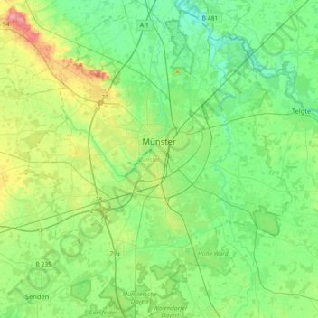
Name: Münster topographic map, elevation, terrain.

Location: Münster, North Rhine-Westphalia, Germany (51.84014 7.47379 52.06003 7.77436)

Average elevation: 61 m

Minimum elevation: 37 m

Maximum elevation: 119 m

Other topographic maps

Click on a map to view its topography, its elevation and its terrain.

Winterberg

Germany > North Rhine-Westphalia > Hochsauerlandkreis

Winterberg experiences a humid continental climate (Köppen Dfb) like most of Germany, however also bordering on subarctic climate (Dfc), thanks to its altitude, with only having an average temperature above 10 °C and September only being barely above it. The summers are short and cool, while the winters are…

Average elevation: 627 m

Wuppertal

Germany > North Rhine-Westphalia > Wuppertal

Uniquely for Germany, it is a "linear city", owing to the steep hillsides along the river Wupper. Its highest hill is the Lichtscheid, which is 351 metres above sea level. The dominant urban centres Elberfeld (historic commercial centre) and Barmen (more industrial) have formed a continuous urbanized area…

Average elevation: 242 m

Brüggen

Germany > North Rhine-Westphalia > Brüggen

Average elevation: 49 m

Hagen

Germany > North Rhine-Westphalia > Hagen

Average elevation: 229 m

Haspe

Germany > North Rhine-Westphalia > Hagen

Average elevation: 256 m

Lennestadt

Germany > North Rhine-Westphalia > Lennestadt

Average elevation: 422 m

Sundern

Germany > North Rhine-Westphalia > Sundern

Average elevation: 381 m

Schleiden

Germany > North Rhine-Westphalia > Schleiden

Average elevation: 451 m

Simmerath

Germany > North Rhine-Westphalia > Simmerath

Average elevation: 482 m

Schwerte

Germany > North Rhine-Westphalia > Schwerte

Average elevation: 156 m

Werden

Germany > North Rhine-Westphalia > Essen > Werden

Average elevation: 121 m

Annen

Germany > North Rhine-Westphalia > Witten

Average elevation: 147 m

Stockum

Germany > North Rhine-Westphalia > Dusseldorf

Average elevation: 35 m