
Thank you for supporting this site ❤️
Make a donation
Make a donation
Atyrau Region topographic map
Click on the map to display elevation.
Thank you for supporting this site ❤️
Make a donation
Make a donation
About this map
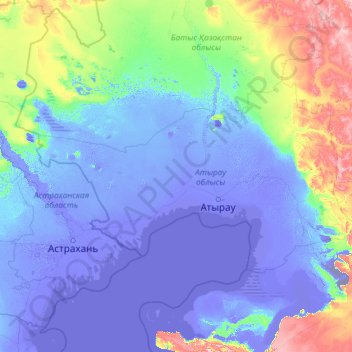
Name: Atyrau Region topographic map, elevation, terrain.
Location: Atyrau Region, Kazakhstan (45.74588 47.04994 49.23275 56.47182)
Average elevation: 12 m
Minimum elevation: -62 m
Maximum elevation: 332 m
Thank you for supporting this site ❤️
Make a donation
Make a donation
Other topographic maps
Click on a map to view its topography, its elevation and its terrain.
Қазақстан
Kazakhstan > Turkistan Region > Keles District > Бірлесу ауылдық округі
Average elevation: 314 m