Geolocate
👉 Easily get elevation data in JSON, GeoTIFF and KML formats using Elevation API
Thank you for supporting this site ❤️
Make a donation

Egan topographic map

Click on the map to display elevation.

👉 Easily get elevation data in JSON, GeoTIFF and KML formats using Elevation API
Thank you for supporting this site ❤️
Make a donation

About this map

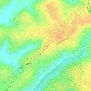
Name: Egan topographic map, elevation, terrain.

Location: Egan, Alimosho, Lagos State, 100265, Nigeria (6.52862 3.21268 6.56862 3.25268)

Average elevation: 17 m

Minimum elevation: 0 m

Maximum elevation: 32 m