
Thank you for supporting this site ❤️
Make a donation
Make a donation
Owen County topographic map
Click on the map to display elevation.
Thank you for supporting this site ❤️
Make a donation
Make a donation
About this map
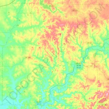
Name: Owen County topographic map, elevation, terrain.
Location: Owen County, Indiana, United States (39.16575 -87.05492 39.47335 -86.63072)
Average elevation: 206 m
Minimum elevation: 151 m
Maximum elevation: 297 m
Thank you for supporting this site ❤️
Make a donation
Make a donation
Other topographic maps
Click on a map to view its topography, its elevation and its terrain.