
Thank you for supporting this site ❤️
Make a donation
Make a donation
Pickering topographic map
Click on the map to display elevation.
Thank you for supporting this site ❤️
Make a donation
Make a donation
Pickering
The city covers an area of 231 square kilometres (89 sq mi) with an elevation of 89 metres (292 ft).
Thank you for supporting this site ❤️
Make a donation
Make a donation
About this map
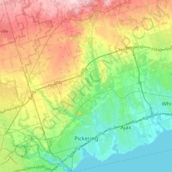
Name: Pickering topographic map, elevation, terrain.
Location: Pickering, Durham Region, Golden Horseshoe, Ontario, Canada (43.79307 -79.22004 44.01076 -79.00859)
Average elevation: 170 m
Minimum elevation: 72 m
Maximum elevation: 351 m
Thank you for supporting this site ❤️
Make a donation
Make a donation