
Thank you for supporting this site ❤️
Make a donation
Make a donation
Ragunda kommun topographic map
Click on the map to display elevation.
Thank you for supporting this site ❤️
Make a donation
Make a donation
About this map
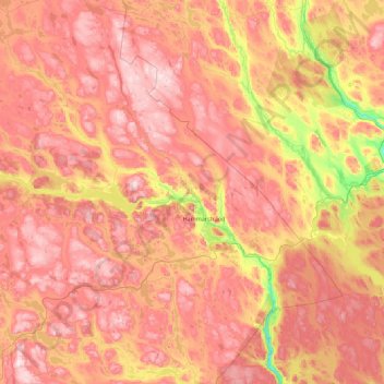
Name: Ragunda kommun topographic map, elevation, terrain.
Location: Ragunda kommun, Jämtland County, Sweden (62.80849 15.22126 63.51481 16.99870)
Average elevation: 315 m
Minimum elevation: 25 m
Maximum elevation: 571 m
Thank you for supporting this site ❤️
Make a donation
Make a donation
Other topographic maps
Click on a map to view its topography, its elevation and its terrain.
Östersund
Though Östersund is in fact affected by the Gulf Stream, it lacks the high frequency of rain or snow following the currents. This is due to the Scandinavian Mountain Range acting as a natural barrier, receiving most of the precipitation, giving Östersund and the surrounding area a rain deficit. Another issue…
Average elevation: 341 m
Thank you for supporting this site ❤️
Make a donation
Make a donation