
Make a donation
Quebec topographic map
Click on the map to display elevation.
Make a donation
Quebec
Quebec's topography is characterized by three main physiographic regions: the Canadian Shield, the St. Lawrence Lowlands, and the Appalachian Mountains. The Canadian Shield, covering about 90% of the province, features rugged terrain with rocky plateaus, rolling hills, and numerous rivers and lakes formed by glacial erosion. The St. Lawrence Lowlands, concentrated around the St. Lawrence River, offer relatively flat and fertile land, making it ideal for agriculture and urban development. In the southeast, the Appalachian region consists of rounded mountains, deep valleys, and forested plateaus. The province's highest point is Mont d'Iberville (Mount Caubvick), reaching 1,652 meters (5,420 feet) in the Torngat Mountains of northern Quebec. This diverse terrain contributes to Quebec's rich natural landscapes and varied ecosystems.
Make a donation
About this map
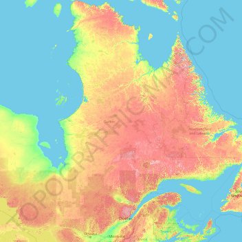
Name: Quebec topographic map, elevation, terrain.
Location: Quebec, Canada (44.99137 -79.76287 62.58250 -57.10749)
Average elevation: 195 m
Minimum elevation: -2 m
Maximum elevation: 1,383 m
Make a donation
Other topographic maps
Click on a map to view its topography, its elevation and its terrain.
Toronto
Despite its deep ravines, Toronto is not remarkably hilly, but its elevation does increase steadily away from the lake. Elevation differences range from 76.5 metres (251 ft) above sea level at the Lake Ontario shore to 209 m (686 ft) ASL near the York University grounds in the city's north end at the…
Average elevation: 113 m
Salmon Arm
Canada > British Columbia > Columbia-Shuswap Regional District > Salmon Arm > Salmon Arm
Average elevation: 479 m
Burnaby
Canada > British Columbia > Metro Vancouver Regional District > Burnaby
Burnaby occupies 98.60 square kilometres (38.07 sq mi) and is located at the geographic centre of the Metro Vancouver area and home to the Metro Vancouver regional government in Metrotown. Situated between the city of Vancouver on the west and Port Moody, Coquitlam, and New Westminster on the east, Burnaby is…
Average elevation: 144 m
Peterborough
Canada > Ontario > Peterborough
Peterborough's topography is largely defined by land formations created by the receding Wisconsian glaciers 10,000–15,000 years ago. The South End and Downtown portions of the City sit on what was the bottom of the glacial Lake Peterborough—part of a glacial spillway created when glacial meltwaters from…
Average elevation: 235 m
Make a donation
Guelph
This region of Ontario has cold winters and warm, humid summers, falling into the Köppen climate classification Dfb zone, with moderately high rainfall and snowfall. It is generally a couple of degrees cooler than lower elevation regions on the Great Lakes shorelines, especially so in winter, the exception…
Average elevation: 344 m
London
Canada > Ontario > London > London
London has a humid continental climate (Köppen Dfb), though due to its downwind location relative to Lake Huron and elevation changes across the city, it is virtually on the Dfa/Dfb (hot summer) boundary favouring the former climate zone to the southwest of the confluence of the South and North Thames Rivers,…
Average elevation: 268 m
Make a donation
Banff
Canada > Alberta > Banff > Banff
Banff is a town within Banff National Park in Alberta, Canada. It is located in Alberta's Rockies along the Trans-Canada Highway, approximately 126 km (78 mi) west of Calgary and 58 km (36 mi) east of Lake Louise. At 1,400 to 1,630 m (4,590 to 5,350 ft) above sea level, Banff is the community with the second…
Average elevation: 1,615 m
Make a donation
Canmore
Canada > Alberta > Town of Canmore
Elevation Place opened in April 2013 as Canmore's new recreation facility. Construction of the facility began in 2012 to replace the Canmore Recreation Centre (the community's old facility). The facility offers an 8-lane 25m lap pool, a world class climbing wall developed by Walltopia, two cardio rooms, a…
Average elevation: 1,565 m
Make a donation
Make a donation
Make a donation
Laurentian Mountains
One of Quebec's official regions is called Laurentides. The mountain range runs through four other regions; Capitale-Nationale, Outaouais, Lanaudière, and Mauricie. The elevation generally ranges from around 500 m (1,640 ft) to 1,000 m (3,280 ft) with Mont Raoul-Blanchard being its highest peak, at 1,166 m…
Average elevation: 348 m
Make a donation
Make a donation
Coast Mountains
Canada > British Columbia > Area A (Seymour Inlet/Knight Inlet)
The Coast Mountains are part of the Pacific Ring of Fire—the ring of volcanoes and associated mountains around the Pacific Ocean—and contain some of British Columbia's highest mountains. Mount Waddington is the highest mountain of the Coast Mountains and the highest that lies entirely within British…
Average elevation: 1,951 m
Make a donation
Cresent Rock Beach
Canada > British Columbia > Metro Vancouver Regional District > Surrey
Average elevation: 29 m
Make a donation
Make a donation
Bird River
Canada > Manitoba > Division No. 1 > Rural Municipality of Alexander
Average elevation: 287 m
Hope
Canada > British Columbia > Fraser Valley Regional District > Hope > Hope
Average elevation: 435 m
Lake Country
Canada > British Columbia > Regional District of Central Okanagan > Lake Country > Lake Country
Average elevation: 528 m
Make a donation
Make a donation
Make a donation
Nose Hill Park
Names currently associated with topographical features in and near Nose Hill Park reflect the impact of the European newcomers and European trade goods on the Peigan. For example, Spy Hill, the westward extension of Nose Hill, derived its present name from the aboriginal practice of communicating with distant…
Average elevation: 1,174 m
Make a donation
Make a donation
Make a donation
Bella Coola
Canada > British Columbia > Central Coast Regional District > Area E (West Bella Coola/Clayton Falls/Tallheo)
There is a 454 km mostly paved road connection by Highway 20 to Williams Lake. The road was built in 1953 by local residents, and features a 15 km ascent from the Valley floor to the Chilcotin plateau, gaining 1600m in elevation to the summit at Heckman Pass, via a number of steep grades & switchbacks. The…
Average elevation: 438 m
Walnut Park
Canada > British Columbia > Metro Vancouver Regional District > Surrey
Average elevation: 49 m
Make a donation
Make a donation
Grande Prairie
Canada > Alberta > Grande Prairie
Grande Prairie is located just north of the 55th parallel north, and is 465 km (289 mi) northwest of Edmonton, lying at an elevation of 669 m (2,195 ft) above sea level. The city is surrounded by farmland to the north, east, and west. To the south lies a vast boreal forest with aspen, tamarack, lodgepole pine,…
Average elevation: 668 m
Make a donation
Make a donation
Make a donation
Mount Steele
Mount Steele is the fifth-highest mountain in Canada and either the tenth- or eleventh-highest peak in North America. Its exact elevation is uncertain. Commonly-quoted figures are 5,073 metres (16,644 ft) and 5,020 metres (16,470 ft). A lower southeast peak of Mt. Steele stands at 4,300 m (14,100 ft).
Average elevation: 4,446 m
Make a donation
Make a donation
Make a donation