
Marijampole County topographic map
Interactive map
Click on the map to display elevation.
About this map
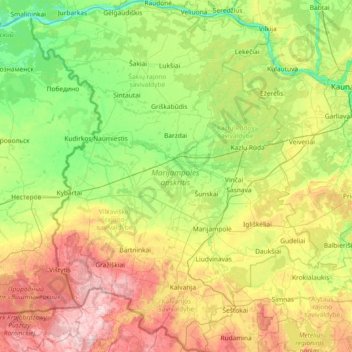
Name: Marijampole County topographic map, elevation, terrain.
Location: Marijampole County, Lithuania (54.25330 22.58924 55.10513 23.79370)
Average elevation: 89 m
Minimum elevation: 3 m
Maximum elevation: 293 m
Other topographic maps
Click on a map to view its topography, its elevation and its terrain.
Vištytis
Lithuania > Marijampole County > Vištytis
Vištytis, Vištyčio seniūnija, Vilkaviškis District Municipality, Marijampole County, Lithuania
Average elevation: 184 m