
Kanchipuram topographic map
Interactive map
Click on the map to display elevation.
About this map
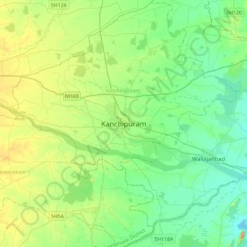
Name: Kanchipuram topographic map, elevation, terrain.
Location: Kanchipuram, Kancheepuram, Tamil Nadu, 631501, India (12.67639 79.54533 12.99639 79.86533)
Average elevation: 82 m
Minimum elevation: 43 m
Maximum elevation: 187 m
Kanchipuram is located at 12°50′19″N 79°42′06″E / 12.8387°N 79.7016°E / 12.8387; 79.7016, 72 km (45 mi) south-west of Chennai on the banks of the Vegavathi River, a tributary of the Palar River. The city covers an area of 11.6 km2 (4.5 sq mi) and has an elevation of 83.2 m (273 ft) above sea level.The land around Kanchipuram is flat and slopes towards the south and east. The soil in the region is mostly clay, with some loam, clay, and sand, which are suitable for use in construction. It has been postulated that the granite required for the Varadaraja Perumal Temple might have been obtained from the Sivaram Hills located 10 miles east of Kanchipuram. The area is classified as a Seismic Zone II region, and earthquakes of up to magnitude 6 on the Richter Scale may be expected. Kanchipuram is subdivided into two divisions –