
Canton 10 topographic map
Interactive map
Click on the map to display elevation.
About this map
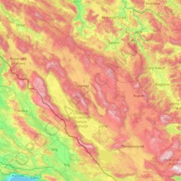
Name: Canton 10 topographic map, elevation, terrain.
Location: Canton 10, Federation of Bosnia and Herzegovina, B&H (43.53826 16.17101 44.49750 17.53506)
Average elevation: 931 m
Minimum elevation: -1 m
Maximum elevation: 2,212 m
Other topographic maps
Click on a map to view its topography, its elevation and its terrain.
Central Bosnia Canton
B&H > Federation of Bosnia and Herzegovina
Central Bosnia Canton, Federation of Bosnia and Herzegovina, B&H
Average elevation: 940 m
Vučipolje
B&H > Federation of Bosnia and Herzegovina > Vučipolje
Vučipolje, Bugojno Municipality, Central Bosnia Canton, Federation of Bosnia and Herzegovina, 70230, B&H
Average elevation: 602 m