
Appenzell Innerrhoden topographic map
Interactive map
Click on the map to display elevation.
About this map
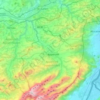
Name: Appenzell Innerrhoden topographic map, elevation, terrain.
Location: Appenzell Innerrhoden, Switzerland (47.23400 9.30971 47.44369 9.61840)
Average elevation: 956 m
Minimum elevation: 420 m
Maximum elevation: 2,479 m
Other topographic maps
Click on a map to view its topography, its elevation and its terrain.
Säntis
Switzerland > Appenzell Innerrhoden > Schwende
Säntis, Schwende, Appenzell Innerrhoden, 9057, Switzerland
Average elevation: 1,938 m