
Cheshire County topographic map
Interactive map
Click on the map to display elevation.
About this map
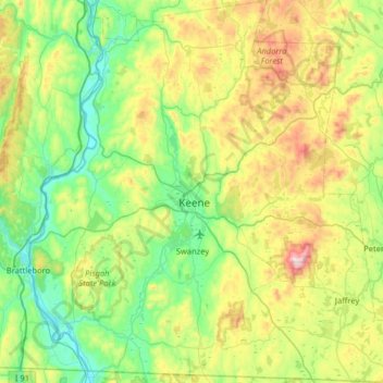
Name: Cheshire County topographic map, elevation, terrain.
Location: Cheshire County, New Hampshire, United States of America (42.71210 -72.55724 43.18196 -71.92899)
Average elevation: 308 m
Minimum elevation: 54 m
Maximum elevation: 944 m
Other topographic maps
Click on a map to view its topography, its elevation and its terrain.
Strafford County
United States of America > New Hampshire
Strafford County, New Hampshire, United States of America
Average elevation: 148 m
Belknap County
United States of America > New Hampshire
Belknap County, New Hampshire, United States of America
Average elevation: 229 m