
Fairfield County topographic map
Interactive map
Click on the map to display elevation.
About this map
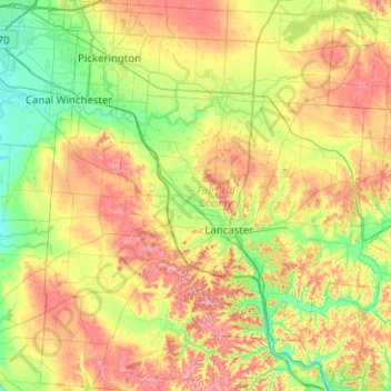
Name: Fairfield County topographic map, elevation, terrain.
Location: Fairfield County, Ohio, USA (39.55440 -82.84294 39.94106 -82.36606)
Average elevation: 282 m
Minimum elevation: 220 m
Maximum elevation: 375 m
Other topographic maps
Click on a map to view its topography, its elevation and its terrain.
Pleasant Heights
USA > Ohio > Pleasant Heights
Pleasant Heights, Columbiana County, Ohio, 26050, USA
Average elevation: 300 m
New Harrisburg
USA > Ohio > New Harrisburg
New Harrisburg, Harrison Township, Carroll County, Ohio, USA
Average elevation: 354 m
Burton Lake
USA > Ohio > Burton Lake
Burton Lake, Burton Township, Geauga County, Ohio, 44021, USA
Average elevation: 348 m
Cheviot Hills
USA > Ohio > Cheviot Hills
Cheviot Hills, Clark County, Ohio, 45505, USA
Average elevation: 321 m