
Bad Rodach topographic map
Interactive map
Click on the map to display elevation.
About this map
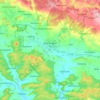
Name: Bad Rodach topographic map, elevation, terrain.
Location: Bad Rodach, Landkreis Coburg, Bayern, 96476, Deutschland (50.27308 10.71232 50.39271 10.86477)
Average elevation: 352 m
Minimum elevation: 284 m
Maximum elevation: 492 m
Other topographic maps
Click on a map to view its topography, its elevation and its terrain.
Heldritt
Deutschland > Bayern > Landkreis Coburg > Bad Rodach
Heldritt, Bad Rodach, Landkreis Coburg, Bayern, 96476, Deutschland
Average elevation: 374 m
Ahlstadt
Deutschland > Bayern > Landkreis Coburg
Ahlstadt, Meeder, Landkreis Coburg, Bayern, Deutschland
Average elevation: 435 m
Sonnefeld
Deutschland > Bayern > Landkreis Coburg
Sonnefeld, Landkreis Coburg, Bayern, 96242, Deutschland
Average elevation: 354 m
Kleingarnstadt
Deutschland > Bayern > Landkreis Coburg
Kleingarnstadt, Ebersdorf b.Coburg, Landkreis Coburg, Bayern, Deutschland
Average elevation: 385 m
Hattersdorf
Deutschland > Bayern > Landkreis Coburg > Seßlach
Hattersdorf, Seßlach, Landkreis Coburg, Bayern, 96145, Deutschland
Average elevation: 300 m
Ahorn
Deutschland > Bayern > Landkreis Coburg
Ahorn, Landkreis Coburg, Bayern, 96482, Deutschland
Average elevation: 333 m
Rödental
Deutschland > Bayern > Landkreis Coburg
Rödental, Landkreis Coburg, Bayern, 96472, Deutschland
Average elevation: 381 m
Neustadt bei Coburg
Deutschland > Bayern > Landkreis Coburg
Neustadt bei Coburg, Landkreis Coburg, Bayern, 96465, Deutschland
Average elevation: 372 m
Ebersdorf b.Coburg
Deutschland > Bayern > Landkreis Coburg
Ebersdorf b.Coburg, Landkreis Coburg, Bayern, 96237, Deutschland
Average elevation: 351 m
Hassenberg
Deutschland > Bayern > Landkreis Coburg > Hassenberg
Hassenberg, Sonnefeld, Landkreis Coburg, Bayern, 96268, Deutschland
Average elevation: 338 m
Scherneck
Deutschland > Bayern > Landkreis Coburg
Scherneck, Untersiemau, Landkreis Coburg, Bayern, 96253, Deutschland
Average elevation: 307 m
Grub am Forst
Deutschland > Bayern > Landkreis Coburg > Grub a.Forst > Grub am Forst
Grub am Forst, Grub a.Forst, Grub am Forst (VGem), Landkreis Coburg, Bayern, 96271, Deutschland
Average elevation: 343 m
Itzgrund
Deutschland > Bayern > Landkreis Coburg
Itzgrund, Landkreis Coburg, Bayern, 96274, Deutschland
Average elevation: 307 m
Seßlach
Deutschland > Bayern > Landkreis Coburg
Seßlach, Landkreis Coburg, Bayern, 96145, Deutschland
Average elevation: 325 m
Lahm
Deutschland > Bayern > Landkreis Coburg > Ebersdorf b.Coburg
Lahm, Ebersdorf b.Coburg, Landkreis Coburg, Bayern, 96271, Deutschland
Average elevation: 361 m
Weitramsdorf
Deutschland > Bayern > Landkreis Coburg
Weitramsdorf, Landkreis Coburg, Bayern, 96479, Deutschland
Average elevation: 341 m
Boderndorf
Deutschland > Bayern > Landkreis Coburg > Neustadt bei Coburg
Boderndorf, Neustadt bei Coburg, Landkreis Coburg, Bayern, 96465, Deutschland
Average elevation: 369 m
Untersiemau
Deutschland > Bayern > Landkreis Coburg
Untersiemau, Landkreis Coburg, Bayern, 96253, Deutschland
Average elevation: 319 m
Meeder
Deutschland > Bayern > Landkreis Coburg
Meeder, Landkreis Coburg, Bayern, 96484, Deutschland
Average elevation: 398 m