
Switzerland topographic map
Interactive map
Click on the map to display elevation.
About this map
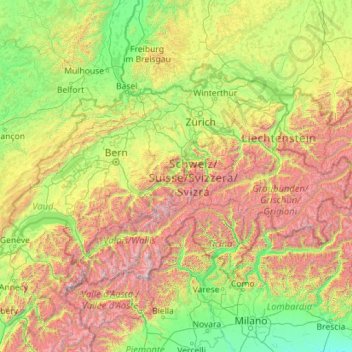
Name: Switzerland topographic map, elevation, terrain.
Location: Switzerland (45.81797 5.95591 47.80846 10.49229)
Average elevation: 1,016 m
Minimum elevation: 41 m
Maximum elevation: 4,564 m
Switzerland lies between latitudes 45° and 48° N, and longitudes 5° and 11° E. It contains three basic topographical areas: the Swiss Alps to the south, the Swiss Plateau or Central Plateau, and the Jura mountains on the west. The Alps are a high mountain range running across the central-south of the country, constituting about 60% of the country's total area. The majority of the Swiss population live in the Swiss Plateau. Among the high valleys of the Swiss Alps many glaciers are found, totalling an area of 1,063 square kilometres (410 sq mi). From these originate the headwaters of several major rivers, such as the Rhine, Inn, Ticino and Rhône, which flow in the four cardinal directions into the whole of Europe. The hydrographic network includes several of the largest bodies of freshwater in Central and Western Europe, among which are included Lake Geneva (also called le Lac Léman in French), Lake Constance (known as Bodensee in German) and Lake Maggiore. Switzerland has more than 1500 lakes, and contains 6% of Europe's stock of fresh water. Lakes and glaciers cover about 6% of the national territory. The largest lake is Lake Geneva, in western Switzerland shared with France. The Rhône is both the main source and outflow of Lake Geneva. Lake Constance is the second largest Swiss lake and, like the Lake Geneva, an intermediate step by the Rhine at the border to Austria and Germany. While the Rhône flows into the Mediterranean Sea at the French Camargue region and the Rhine flows into the North Sea at Rotterdam in the Netherlands, about 1,000 kilometres (620 miles) apart, both springs are only about 22 kilometres (14 miles) apart from each other in the Swiss Alps.
Other topographic maps
Click on a map to view its topography, its elevation and its terrain.
Mobile
United States > Alabama > Mobile County
Mobile, Mobile County, Alabama, United States
Average elevation: 18 m
Mauritius
Mauritius
Average elevation: 0 m
Jim Edgar Panther Creek State Fish and Wildlife Area
United States > Illinois > Cass County
Jim Edgar Panther Creek State Fish and Wildlife Area, 10149, Cass County, Illinois, 62627, United States
Average elevation: 183 m
Oju Ota
Nigeria > Ogun State > Yewa South
Oju Ota, Yewa South, Ogun State, Nigeria
Average elevation: 40 m
Lagos
Nigeria > Lagos State > Lagos Island
Lagos, Lagos Island, Lagos State, 100242, Nigeria
Average elevation: 5 m
Double Tree
United States > Alabama > Madison County > Huntsville
Double Tree, Huntsville, Madison County, Alabama, 35802, United States
Average elevation: 263 m
Copenhagen
Denmark > Capital Region of Denmark
Copenhagen, Copenhagen Municipality, Capital Region of Denmark, 1357, Denmark
Average elevation: 9 m
Villandry
France > Centre-Val de Loire > Indre-et-Loire
Villandry, Tours, Indre-et-Loire, Centre-Val de Loire, Metropolitan France, 37510, France
Average elevation: 70 m
Bahía Blanca
Bahía Blanca, Partido de Bahía Blanca, Buenos Aires, Argentina
Average elevation: 37 m
Madurai
India > Tamil Nadu > Madurai South
Madurai, Madurai South, Madurai District, Tamil Nadu, India
Average elevation: 137 m
Itere
Nigeria > Ogun State > Ado Odo/Ota
Itere, Ado Odo/Ota, Ogun State, Nigeria
Average elevation: 7 m
Ashaka
Nigeria > Gombe State > Funakaye
Ashaka, Funakaye, Gombe State, Nigeria
Average elevation: 260 m
Ikare
Nigeria > Ondo State > Akoko North East
Ikare, Akoko North East, Ondo State, Nigeria
Average elevation: 440 m
Neuville
France > Auvergne-Rhône-Alpes > Puy-de-Dôme
Neuville, Clermont-Ferrand, Puy-de-Dôme, Auvergne-Rhône-Alpes, Metropolitan France, 63160, France
Average elevation: 405 m
Huntsville
United States > Alabama > Madison County
Huntsville, Madison County, Alabama, United States
Average elevation: 232 m
Dhaka
Dhaka, Dhaka Metropolitan, Dhaka District, Dhaka Division, 1215, Bangladesh
Average elevation: 7 m
Buenos Aires
Argentina > Autonomous City of Buenos Aires
Buenos Aires, Comuna 1, Autonomous City of Buenos Aires, Argentina
Average elevation: 9 m
Denmark
Denmark
Average elevation: 30 m
Canada
Canada
Average elevation: 254 m
Zurndorf
Austria > Burgenland > Bezirk Neusiedl am See
Zurndorf, Bezirk Neusiedl am See, Burgenland, 2424, Austria
Average elevation: 150 m
New Mills
United Kingdom > England > Derbyshire > High Peak
New Mills, High Peak, Derbyshire, England, United Kingdom
Average elevation: 251 m
Priozersk
Russia > Leningrad oblast > Käkisalmi District
Priozersk, Приозерское городское поселение, Käkisalmi District, Leningrad oblast, Northwestern Federal District, 188760, Russia
Average elevation: 12 m
Bukura
Kenya > Kakamega County > Butere
Bukura, Butere, Kakamega County, Western, Kenya
Average elevation: 1,434 m
Banja Luka
Bosnia and Herzegovina > Republika Srpska > City of Banja Luka
Banja Luka, City of Banja Luka, Republika Srpska, Bosnia and Herzegovina
Average elevation: 295 m
Ika
Croatia > Primorje-Gorski Kotar County > Grad Opatija
Ika, Grad Opatija, Primorje-Gorski Kotar County, 51415, Croatia
Average elevation: 143 m
Port Arthur
Port Arthur, Tasman, Tasmania, 7182, Australia
Average elevation: 153 m
Cardiff
United Kingdom > Wales > Cardiff
Cardiff, Wales, CF10 2AF, United Kingdom
Average elevation: 55 m
Village of Arcade
United States > New York > Wyoming County
Village of Arcade, Town of Arcade, Wyoming County, New York, United States
Average elevation: 478 m
Kara-Kulja
Kyrgyzstan > Osh Region > Kara-Kulja District
Kara-Kulja, Kara-Kulja District, Osh Region, Kyrgyzstan
Average elevation: 1,443 m
Jackson Hole
United States > Oklahoma > Comanche County
Jackson Hole, Comanche County, Oklahoma, United States
Average elevation: 406 m
Vulcan City
United States > Alabama > Jefferson County > Birmingham
Vulcan City, Birmingham, Jefferson County, Alabama, 35207, United States
Average elevation: 181 m