
Romania topographic map
Interactive map
Click on the map to display elevation.
About this map
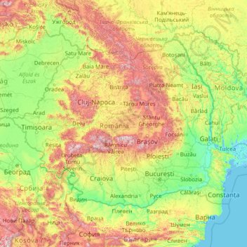
Name: Romania topographic map, elevation, terrain.
Location: Romania (43.61868 20.26198 48.26547 30.04543)
Average elevation: 355 m
Minimum elevation: -3 m
Maximum elevation: 2,426 m
Other topographic maps
Click on a map to view its topography, its elevation and its terrain.
Piatra Fântânele
Piatra Fântânele, Bistrița-Năsăud, 427363, Romania
Average elevation: 1,080 m
Retezat National Park
Retezat National Park, Hunedoara, Romania
Average elevation: 1,443 m