
Campeche topographic map
Interactive map
Click on the map to display elevation.
About this map
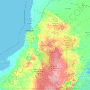
Name: Campeche topographic map, elevation, terrain.
Location: Campeche, Mexico (17.81242 -92.46903 20.84833 -89.12123)
Average elevation: 63 m
Minimum elevation: -3 m
Maximum elevation: 373 m
Campeche is a relatively flat area of Mexico with 523 km (325 mi) of shoreline on the Gulf of Mexico. Most of the surface is of sedimentary rock much of which is from marine origin. The area with the highest elevations is near the borders with Guatemala and Quintana Roo. Notable elevations include Cerro Champerico, Cerro los Chinos, Cerro El Ramonal, Cerro El Doce, and Cerro El Gavilán. However, these hills are separated by large expanses of lower flat land. In the south of the municipality of Champotón begin a series of rolling hills known as the Sierra Alta or Puuc, which extend northeast to Bolonchen and then into the state of Yucatán. These have only an average altitude of between forty and sixty metres (130 and 200 ft) with some reaching 100 metres (330 ft). There other areas of these rolling hills, near the city of Campeche with main ones known as Maxtum, Boxol and El Morro. Another set is called the Sierra Seybaplaya in the center of the state.
Other topographic maps
Click on a map to view its topography, its elevation and its terrain.