
Almaty Region topographic map
Interactive map
Click on the map to display elevation.
About this map
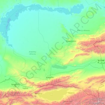
Name: Almaty Region topographic map, elevation, terrain.
Location: Almaty Region, Kazakhstan (42.21084 73.72202 47.33089 82.58773)
Average elevation: 1,190 m
Minimum elevation: 321 m
Maximum elevation: 6,882 m
Other topographic maps
Click on a map to view its topography, its elevation and its terrain.
Aksu District
Aksu District, Almaty Region, Kazakhstan
Average elevation: 908 m
Alakol
Alakol, Alakol District, Almaty Region, Kazakhstan
Average elevation: 495 m
Lake Kaindy
Lake Kaindy, Кегенский район, Almaty Region, Kazakhstan
Average elevation: 2,162 m