
Mechi topographic map
Interactive map
Click on the map to display elevation.
About this map
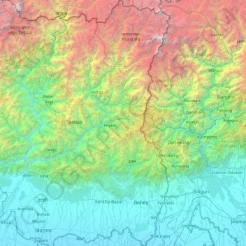
Name: Mechi topographic map, elevation, terrain.
Location: Mechi, Eastern Development Region, Nepal (26.36103 87.44430 27.95305 88.20153)
Average elevation: 1,902 m
Minimum elevation: 59 m
Maximum elevation: 8,411 m
Other topographic maps
Click on a map to view its topography, its elevation and its terrain.
Mount Everest
Nepal > Eastern Development Region > Khumjung
Mount Everest, Khumjung, Solukhumbu, Sagarmatha, Eastern Development Region, Nepal
Average elevation: 7,841 m
Dokhu
Nepal > Eastern Development Region > Suketar
Dokhu, Suketar, Phungling, Taplejung, Eastern Development Region, Nepal
Average elevation: 1,989 m
Thangnak
Nepal > Eastern Development Region > Thangnak
Thangnak, Solukhumbu, Sagarmatha, Eastern Development Region, Nepal
Average elevation: 4,810 m
Koshi
Nepal > Eastern Development Region
Koshi, Eastern Development Region, Nepal
Average elevation: 1,899 m
Island Peak
Nepal > Eastern Development Region > Khumjung
Island Peak, Khumjung, Solukhumbu, Sagarmatha, Eastern Development Region, Nepal
Average elevation: 5,461 m
Mahalangur Himal
Nepal > Eastern Development Region > Makalu
Mahalangur Himal, Makalu, Sankhuwasabha, Koshi, Eastern Development Region, Nepal
Average elevation: 4,695 m
Lhotse Shar
Nepal > Eastern Development Region > Khumjung
Lhotse Shar, Khumjung, Solukhumbu, Sagarmatha, Eastern Development Region, Nepal
Average elevation: 7,153 m