
Saaremaa topographic map
Interactive map
Click on the map to display elevation.
Saaremaa
More than 10,000 years ago the first parts of Saaremaa arose from the Baltic Ice Lake. The uplift of the Earth's crust is continuing even today, at 2 millimetres (0.079 in) per year. The West Estonian islands are lowlying plains resting on limestone, their average elevation being about 15 metres (49 ft) above sea level. Limestone has become denuded in a great number of places, resulting in cliffs, limestone pits and quarries at Mustjala, Ninase, Pulli, Üügu and Kaugatuma.
About this map
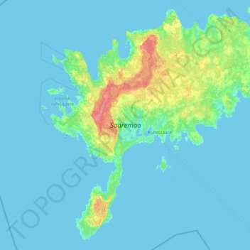
Name: Saaremaa topographic map, elevation, terrain.
Location: Saaremaa, Saaremaa vald, Saare maakond, Estonia (57.90667 21.82850 58.64229 23.32865)
Average elevation: 5 m
Minimum elevation: -1 m
Maximum elevation: 57 m
Other topographic maps
Click on a map to view its topography, its elevation and its terrain.
Estonia
Estonia lies on the eastern shores of the Baltic Sea immediately across the Gulf of Finland, on the level northwestern part of the rising East European platform between 57.3° and 59.5° N and 21.5° and 28.1° E. Average elevation reaches only 50 metres (164 ft) and the country's highest point is the Suur…
Average elevation: 142 m