Geolocate

East Delhi topographic map

Interactive map

Click on the map to display elevation.

About this map

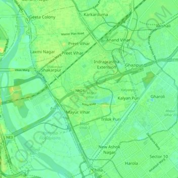
Name: East Delhi topographic map, elevation, terrain.

Location: East Delhi, Delhi, India (28.58486 77.26852 28.65582 77.34206)

Average elevation: 205 m

Minimum elevation: 195 m

Maximum elevation: 214 m

Other topographic maps

Click on a map to view its topography, its elevation and its terrain.

Jasola

India > Delhi

Jasola, South East Delhi, Delhi, India

Average elevation: 207 m

Rangpuri

India > Delhi > New Delhi > Rangpuri

Rangpuri, New Delhi, Delhi, 110037, India

Average elevation: 244 m

Old Delhi

India > Delhi > Delhi

Old Delhi, Delhi, Central Delhi, Delhi, India

Average elevation: 218 m

Yamuna River

India > Delhi > Delhi

Yamuna River, Doctor KB Hedgewar Marg, Kashmiri Gate, Majnu Ka Tila, Delhi, Central Delhi, Delhi, 110054, India

Average elevation: 212 m

Najafgarh

India > Delhi

Sai Dham, Najafgarh, South West Delhi, Delhi, India

Average elevation: 214 m

Chanakyapuri

India > Delhi > New Delhi

Chanakyapuri, New Delhi, Delhi, India

Average elevation: 228 m