
Kinnaur topographic map
Interactive map
Click on the map to display elevation.
About this map
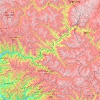
Name: Kinnaur topographic map, elevation, terrain.
Location: Kinnaur, Himachal Pradesh, India (31.09756 77.74825 32.08850 79.01238)
Average elevation: 4,303 m
Minimum elevation: 1,371 m
Maximum elevation: 6,651 m
Most of Kinnaur enjoys a temperate climate due to its high elevation, with long winters from October to May, and short summers from June to September. The lower parts of the Sutlej Valley and the Baspa Valley receive monsoon rains. The Baspa valley receives highest rainfall in July month. The upper areas of the valleys fall mainly in the rain-shadow area. These areas are considered to be arid regions, similar to the climate of Tibet and Central Asian countries study by the IIT Delhi in 2016 established that Kinnaur district has the cleanest air in the country
Other topographic maps
Click on a map to view its topography, its elevation and its terrain.
Sangla
India > Himachal Pradesh > Kinnaur
Sangla, Kinnaur, Himachal Pradesh, India
Average elevation: 4,250 m
Kilba
India > Himachal Pradesh > Kilba
Kilba, Sangla, Kinnaur, Himachal Pradesh, India
Average elevation: 2,367 m
Lehar
India > Himachal Pradesh > Lehar
Lehar, Mandi, Himachal Pradesh, India
Average elevation: 1,881 m
Gaggal
India > Himachal Pradesh > Gaggal
Gaggal, Kangra, Himachal Pradesh, 176001, India
Average elevation: 755 m
Lahul and Spiti
Lahul and Spiti, Himachal Pradesh, India
Average elevation: 4,286 m
Sunni
India > Himachal Pradesh > Sunni > Sunni
Sunni, Mandi, Himachal Pradesh, India
Average elevation: 768 m