
Nagaland topographic map
Interactive map
Click on the map to display elevation.
About this map
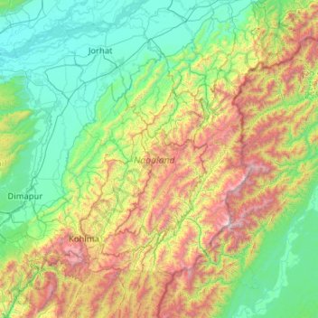
Name: Nagaland topographic map, elevation, terrain.
Location: Nagaland, India (25.19870 93.32670 27.03580 95.24238)
Average elevation: 824 m
Minimum elevation: 67 m
Maximum elevation: 3,721 m
Nagaland is largely a mountainous state. The Naga Hills rise from the Brahmaputra Valley in Assam to about 610 metres (2,000 ft) and rise further to the southeast, as high as 1,800 metres (6,000 ft). Mount Saramati at an elevation of 3,841.00 metres (12,601.70 ft) is the state's highest peak; this is where the Naga Hills merge with the Patkai Range in which form the boundary with Burma. Rivers such as the Doyang and Diphu to the north, the Barak river in the southwest, dissect the entire state. 20 percent of the total land area of the state is covered with wooded forest, a haven for flora and fauna. The evergreen tropical and the sub tropical forests are found in strategic pockets in the state.
Other topographic maps
Click on a map to view its topography, its elevation and its terrain.