
Amur Oblast topographic map
Interactive map
Click on the map to display elevation.
About this map
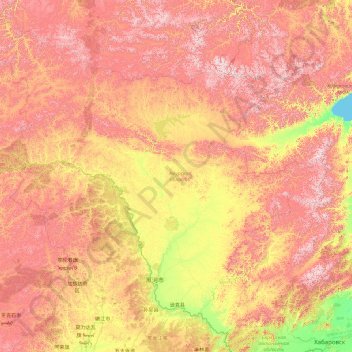
Name: Amur Oblast topographic map, elevation, terrain.
Location: Amur Oblast, Far Eastern Federal District, Russia (48.85346 119.65539 57.06051 134.92091)
Average elevation: 634 m
Minimum elevation: 0 m
Maximum elevation: 2,205 m
Dwarf Siberian pine and alpine tundra grow at higher elevations and larch forests with small stands of flat-leaved birch and pine forests grow alongside the river plains. These larch and fir-spruce forests form the watershed of the Selemdzha River. The Bureya and Arkhara Rivers, southeast of the Selemdza, have the richest remaining forests in the oblast with Korean pine, Schisandra chinensis, Mongolian Oak, and other Manchurian flora. The Zeya–Bureya Plain, located between the Zeya, Amur, and Bureya Rivers, has the highest biodiversity in Amur Oblast. Much of this plain has been burned for agriculture, but large patches still remain. Japanese Daurian and Far Eastern western cranes nest here, as well as a host of other rare birds.
Other topographic maps
Click on a map to view its topography, its elevation and its terrain.
Belogorsk
Russia > Amur Oblast > Belogorsk
Belogorsk, городской округ Белогорск, Amur Oblast, Far Eastern Federal District, Russia
Average elevation: 171 m
Надежденское
Russia > Amur Oblast > Надежденское
Надежденское, Ivanovsky District, Amur Oblast, Far Eastern Federal District, Russia
Average elevation: 157 m
Blagoveshchensk
Russia > Amur Oblast > Blagoveshchensk
Blagoveshchensk, городской округ Благовещенск, Amur Oblast, Far Eastern Federal District, Russia
Average elevation: 170 m
Zeya River
Zeya River, Shimanovsky District, Amur Oblast, Far Eastern Federal District, 676243, Russia
Average elevation: 500 m
Zavitinsky District
Zavitinsky District, Amur Oblast, Far Eastern Federal District, 676870, Russia
Average elevation: 239 m
Stanovoy Range
Stanovoy Range, Tyndinsky District, Amur Oblast, Far Eastern Federal District, Russia
Average elevation: 1,141 m