
Gongola topographic map
Interactive map
Click on the map to display elevation.
About this map
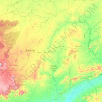
Name: Gongola topographic map, elevation, terrain.
Location: Gongola, Kirfi, Bauchi, Nigeria (9.47581 9.22841 11.11344 12.06232)
Average elevation: 457 m
Minimum elevation: 112 m
Maximum elevation: 1,703 m
Other topographic maps
Click on a map to view its topography, its elevation and its terrain.
Rahama Bauchi
Nigeria > Bauchi > Rahama > Rahama Bauchi
Rahama Bauchi, Rahama, Toro, Bauchi, Nigeria
Average elevation: 781 m
Dass
Nigeria > Bauchi > Bununu Central > Dass
Dass, Bununu Central, Dass, Bauchi, Nigeria
Average elevation: 658 m