
Chenab River topographic map
Interactive map
Click on the map to display elevation.
About this map
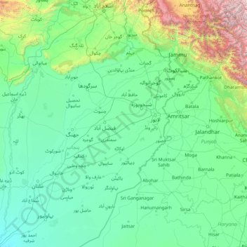
Name: Chenab River topographic map, elevation, terrain.
Location: Chenab River, Gujrānwāla District, Punjab, 35460, Pakistan (29.34907 71.01066 33.39077 76.97590)
Average elevation: 507 m
Minimum elevation: 91 m
Maximum elevation: 6,453 m
Other topographic maps
Click on a map to view its topography, its elevation and its terrain.
Bahawalpur
Pakistan > Punjab > Bahawalpur
Bahawalpur, Bahawalpur Tehsil, Punjab, 63100, Pakistan
Average elevation: 118 m
Love Garden
Love Garden, Faisal Town, Lahore, Lahore District, Punjab, Pakistan
Average elevation: 214 m
Sangla Hill
Pakistan > Punjab > Sangla Hill
Sangla Hill, Faisalābād District, Punjab, Pakistan
Average elevation: 196 m