
Florida topographic map
Interactive map
Click on the map to display elevation.
About this map
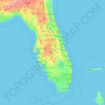
Name: Florida topographic map, elevation, terrain.
Location: Florida, United States (24.39631 -87.63490 31.00097 -79.97431)
Average elevation: 6 m
Minimum elevation: -3 m
Maximum elevation: 111 m
Economic prosperity in the 1920s stimulated tourism to Florida and related development of hotels and resort communities. Combined with its sudden elevation in profile was the Florida land boom of the 1920s, which brought a brief period of intense land development. Devastating hurricanes in 1926 and 1928, followed by the Great Depression, brought that period to a halt. Florida's economy did not fully recover until the military buildup for World War II.
Other topographic maps
Click on a map to view its topography, its elevation and its terrain.
Pinellas County
United States > Florida > Pinellas County
Pinellas County, Florida, United States
Average elevation: 4 m
Santa Rosa County
United States > Florida > Santa Rosa County
Santa Rosa County, Florida, United States
Average elevation: 32 m
Leon County
United States > Florida > Leon County
Leon County, Florida, United States
Average elevation: 38 m