
Windham County topographic map
Interactive map
Click on the map to display elevation.
About this map
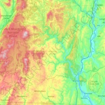
Name: Windham County topographic map, elevation, terrain.
Location: Windham County, Vermont, United States of America (42.72696 -73.00813 43.26285 -72.43249)
Average elevation: 444 m
Minimum elevation: 57 m
Maximum elevation: 1,195 m
Other topographic maps
Click on a map to view its topography, its elevation and its terrain.
Rutland County
United States of America > Vermont
Rutland County, Vermont, United States of America
Average elevation: 363 m