Kodiak Island topographic map
Interactive map
Click on the map to display elevation.
About this map
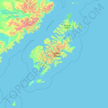
Name: Kodiak Island topographic map, elevation, terrain.
Location: Kodiak Island, Alaska, United States of America (55.69991 -156.90315 59.01789 -151.69051)
Average elevation: 84 m
Minimum elevation: -1 m
Maximum elevation: 2,289 m
Other topographic maps
Click on a map to view its topography, its elevation and its terrain.
North Slope
United States of America > Alaska
North Slope, Alaska, United States of America
Average elevation: 214 m
Southeast Fairbanks
United States of America > Alaska > Copper Center
Southeast Fairbanks, Richardson Highway, Copper Center, Unorganized Borough, Alaska, United States of America
Average elevation: 856 m
Aleutians East
United States of America > Alaska
Aleutians East, Alaska, United States of America
Average elevation: 23 m