
Awgu topographic map
Interactive map
Click on the map to display elevation.
Awgu
Awgu is drained mainly by seasonal finger-like springs and streams. They dry up during the dry season (November- March) and yield more water in the wet season (April to October). Most of the streams obtain their source from top of the hills and flow downhill. In the rainy season runoffs are collected by the streams thereby increasing their volume and velocity. Due to the muddy nature of the streams channels, the water is usually colored after heavy downpour. The streams carry a lot of debris as they flow from their source (hill top) to the settlement areas down hill (lower course). The stream load (debris) makes the water dirty therefore not suitable for domestic use. Many people that reside at the very lower course of the streams are affected and they have to trek up to the middle course (foot of the hills) to collect water. The area lies within the guinea Savannah vegetation zone. Vegetation in the study area varies with topography. Natural vegetation is denser at the valley and sparse at the top of the hills. Graminoids cover the area while trees are dominant on the plain. The top and slope face of the hills are more covered by grasses such as Andropogon gayanus, Ctenium spp, Hyparrhenia barteri etc. The common tree species found are Isoberlina doka, Anona senegalensis etc. This pattern of vegetation has been ascribed to relative dryness during the dry season, favorable soil conditions and human interference in bush burning. On the hills, shattered sites have trees dominating in colonies and that these colonies in shattered sites are characterized by favorable soils and soil water holding capacity
About this map
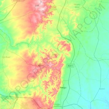
Name: Awgu topographic map, elevation, terrain.
Location: Awgu, Enugu, Nigeria (6.00622 7.37104 6.33880 7.53236)
Average elevation: 188 m
Minimum elevation: 43 m
Maximum elevation: 493 m
Other topographic maps
Click on a map to view its topography, its elevation and its terrain.