Geolocate

Falkland Islands topographic map

Interactive map

Click on the map to display elevation.

About this map

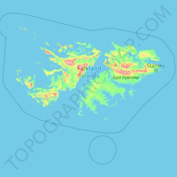
Name: Falkland Islands topographic map, elevation, terrain.

Location: Falkland Islands (-53.11868 -61.77268 -50.79730 -57.36624)

Average elevation: 10 m

Minimum elevation: -1 m

Maximum elevation: 668 m

Other topographic maps

Click on a map to view its topography, its elevation and its terrain.

Mount Usborne

Falkland Islands

Mount Usborne, Islas Malvinas, Falkland Islands

Average elevation: 459 m

East Falkland

Falkland Islands

East Falkland, Islas Malvinas, Falkland Islands

Average elevation: 24 m

West Falkland

Falkland Islands

West Falkland, Islas Malvinas, Falkland Islands

Average elevation: 32 m