
Malaysia topographic map
Interactive map
Click on the map to display elevation.
About this map
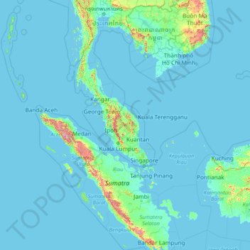
Name: Malaysia topographic map, elevation, terrain.
Location: Malaysia (0.85382 98.93721 7.66673 119.58335)
Average elevation: 52 m
Minimum elevation: -3 m
Maximum elevation: 3,124 m
The two parts of Malaysia, separated from each other by the South China Sea, share a largely similar landscape in that both Peninsular and East Malaysia feature coastal plains rising to hills and mountains. Peninsular Malaysia, containing 40 per cent of Malaysia's land area, extends 740 km (460 mi) from north to south, and its maximum width is 322 km (200 mi). It is divided between its east and west coasts by the Titiwangsa Mountains, rising to a peak elevation of 2,183 metres (7,162 ft) at Mount Korbu, part of a series of mountain ranges running down the centre of the peninsula. These mountains are heavily forested, and mainly composed of granite and other igneous rocks. Much of it has been eroded, creating a karst landscape. The range is the origin of some of Peninsular Malaysia's river systems. The coastal plains surrounding the peninsula reach a maximum width of 50 kilometres (31 mi), and the peninsula's coastline is nearly 1,931 km (1,200 mi) long, although harbours are only available on the western side.
Other topographic maps
Click on a map to view its topography, its elevation and its terrain.
Section 12
Malaysia > Selangor > SA > Section 12
Section 12, SA, Selangor, 40675, Malaysia
Average elevation: 19 m
Kampung Pandan
Malaysia > Kuala Lumpur > Kampung Pandan
Kampung Pandan, Kuala Lumpur, 50988, Malaysia
Average elevation: 49 m
Bandar Menjalara
Malaysia > Kuala Lumpur > Bandar Menjalara
Bandar Menjalara, Kuala Lumpur, Malaysia
Average elevation: 83 m
Kampung Sungai Raya
Malaysia > Selangor > Kampung Sungai Raya
Kampung Sungai Raya, Selangor, 43100, Malaysia
Average elevation: 68 m
Kampung Desa Pahlawan
Malaysia > Kuala Lumpur > Kampung Desa Pahlawan
Kampung Desa Pahlawan, Kuala Lumpur, 50600, Malaysia
Average elevation: 51 m
Section 19
Malaysia > Selangor > SA > Section 19
Section 19, SA, Selangor, 40200, Malaysia
Average elevation: 10 m
Melaka City
Malaysia > Malacca > Melaka City
Melaka City, Central Malacca, Malacca, 75000, Malaysia
Average elevation: 12 m
Alor Setar
Malaysia > Kedah > Alor Setar
Alor Setar, Kota Setar, Kedah, 05672, Malaysia
Average elevation: 9 m
George Town
Malaysia > Penang > George Town
George Town, Northeast Penang Island District, Penang, 10000, Malaysia
Average elevation: 38 m
Subang Jaya
Malaysia > Selangor > Subang Jaya
Subang Jaya, Selangor, 47610, Malaysia
Average elevation: 35 m
Chini Lake
Malaysia > Pahang > Paloh Hinai
Chini Lake, C108, Paloh Hinai, Pahang, Malaysia
Average elevation: 40 m
Perdana Botanical Gardens
Perdana Botanical Gardens, Bukit Petaling, Federal Hill, Kuala Lumpur, Malaysia
Average elevation: 54 m
Kuala Nerang
Malaysia > Kedah > Kuala Nerang
Kuala Nerang, Pdg Terap, Kedah, 06300, Malaysia
Average elevation: 31 m
Air Itam Dam
Malaysia > Penang > Titi Teras
Air Itam Dam, Jl. Balik Pulau, Titi Teras, Barat Daya, Penang, 11500, Malaysia
Average elevation: 317 m
Federal Territory of Kuala Lumpur
Malaysia > Federal Territory of Kuala Lumpur
Federal Territory of Kuala Lumpur, Malaysia
Average elevation: 119 m
Malay Peninsula
Malay Peninsula, 64, Damak, Pahang, 27030, Malaysia
Average elevation: 131 m